
Bass Harbor Head Lighthouse

Longitutde: 68°20'09"W
Latitude: 44°13'19"N
Dg2
(Seawall to Bass Harbor). Pink, fine-grained granite with a distinctive sugary texture. Contains abundant veins of coarser quartz and feldspar
SDcit
Tuffs: Gray crystal and lithic tuffs. Many of the beds appear wate-laid, but ash falls and flows are present.
SDcif
Felsites and flows: Blue-gray to light brown felsites and gray to brown dacite flows.
Figure 1. After Chapman et al, 1988
After exploring the natural sea wall at Seawall Beach, continue down the coastline until you reach the Bass Harbor Head Lighthouse. Take the path to the east and walk down the stairs, where you will find yourself standing on Seawall granite.
The Seawall granite has a light pinkish grey colour and known for its sugary texture. It is one of the youngest granites on the island, formed 370mya inside a cooling magma chamber.
The cracks and lines present in the photo to the left are called fractures. They provide evidence that tectonic activity occurred during the formation of Mount Desert Island. There are two main fracture trends: northwest to southeast, and east to west. If you look at fractures at different locations on MDI you will notice that these two trends are very common. This is because the same tectonic activities influenced the entire island.
Looking closely at the granite you will see some of the following minerals present in the granite:
-Microcline, KAlSi3O8 , a light coloured feldspar
- Hematite, Fe2O3, red mineral with a sparkly luster. Red due to iron oxide
- Biotite, K(Mg,Fe2+3)(Al,Fe3+)Si3O10(OH,F)2 , which is black mica crystals
- Quartz, SiO2 ,a milky coloured crystal which is the most abundant mineral found at the Earth’s surface.

Image 1. Seawall granite with fractures
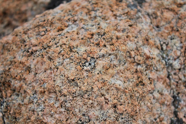
Image 2. Zoomed in view of Seawall granite

Pockets, or nodules, of quartz can also be seen in the granite. They were formed in the magma chamber and intruded into the granite where there were planes of weaknesses.
Image 3. Pockets of Quartz
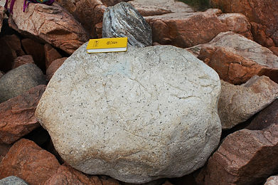
If you walk south towards the Bass Harbor Lighthouse, you can spot several boulders which were formed at different parts of the island, picked up by glaciers and deposited at Bass Harbor.

(Left)
Image 4. Ellsworth Schist
(Right)
Image 5. Cranberry Island Volcanic Tuff
(Right)
Image 6.
Gabbro - diorite

Geomorphology

Image 7. Seawall granite cliffs
Bass Harbor Head Lighthouse is located at an un-protected ledge and cliff on Southern Mount Desert Island. Here, we can see evidence of post Pliestocene wave erosion. This was a time when sea levels rose due to fluctuations from the Quaternary glaciation period 2.58 MYA. We can see this evidence in the form of wave cut benches or platforms at the area of the Bass Harbor Head Lighthouse. They are exposed mainly at low tide and below in fig. 1. 2 we can see evidence of this geological feature in the topographic profile.

Fig. 1.2 Topographic profile of Bass Harbor Cliffs
History of the Lighthouse

You might be wondering, why is there a lighthouse at Bass Harbor?
The sharp and rugged rocks along the coastline makes it a very dangerous area for boats to come near. It was declared that there was “sufficient need” to ensure safety. Bass Harbor Lighthouse was built in 1858 and reaches 56 meters above sea water. The lighthouse belongs to the U.S Coast Guard and still in use today.
Image 8. Bass Harbor Lighthouse, from National Park Service.
References Cited
Anderson, Walter A. 1988. Bedrock Geology of Mount Desert Island: Maine Geological Survey, scale 1:50,000, 1 sheet.
Braun, Duane D., and Ruth Braun. Guide to the Geology of Mount Desert Island and Acadia National Park. Berkeley, CA: North Atlantic, 2016. Print.
Hall, Sarah. Personal communication, fall 2016.
Hartford, Greg A., 2015. Bass Harbor Head Light: http://www.acadiamagic.com/BassHarborLight.html (accessed Novemeber, 2016).